Name
Total length
Mouth
Mouth
Mouth elevation
Source
Source
Source elevation
Catchment Area
Aire
114 kmRiver Ouse, Yorkshire near Airmyn
53°43′35″N 0°54′22″W / 53.72639°N 0.90611°W / 53.72639; -0.90611 (Mouth of River Aire ) 3 mMalham Tarn
54°5′45″N 2°10′0″W / 54.09583°N 2.16667°W / 54.09583; -2.16667 (Source of River Aire ) 377 m856 km²[6]
Arkle Beck
17 km approx
River Swale at Reeth
NY 987 030 177 m
Arkengarthdale Moor
NY 989 088 477 m
Ashfold Side Beck
9 km Approx
River Nidd near Pateley Bridge
SE 152 664 117 m
Ashfold Gill Head
SE 073 685 504 m
Bain
3.95 kmRiver Ure near Bainbridge
54°18′45″N 2°6′3″W / 54.31250°N 2.10083°W / 54.31250; -2.10083 (Mouth of River Bain ) 210 mSemer Water
54°17′3″N 2°7′22″W / 54.28417°N 2.12278°W / 54.28417; -2.12278 (Source of River Bain ) 252 mNot available
Barney Beck
6 km approx
River Swale at Healaugh
SE 015 984 186 m
Reeth High Moor
NY 963 012 451 m
Not available
Birkdale Beck
6 km approx
River Swale near Keld
NY 872 013 341 m
Beck Meetings
NY 820 035 455 m
Not available
Bishopdale Beck
11 km approx
River Ure near Aysgarth
SE 019 879 144 m
Dale Head
SD 961 826 218 m
Not available
River Burn
13 km approx
River Ure at Masham
SE 230 797 70 m
Masham Moor
SE 113 799 292 m
Calder
71 kmRiver Aire
53°43′54″N 1°21′33″W / 53.73167°N 1.35917°W / 53.73167; -1.35917 (Mouth of River Calder ) 14 mHeald Moor, near Todmorden
53°44′23″N 2°9′53″W / 53.73972°N 2.16472°W / 53.73972; -2.16472 (Source of River Calder ) 220 m930 km²[7]
Colne
20.6 kmRiver Calder near Bradley
53°40′49″N 1°43′52″W / 53.68028°N 1.73111°W / 53.68028; -1.73111 (Mouth of River Colne ) 52 mConfluence of Redbrook Clough and Haigh Clough
53°36′19″N 1°57′28″W / 53.60528°N 1.95778°W / 53.60528; -1.95778 (Source of River Colne ) 234 m245 km²[8]
Cover
22 kmRiver Ure near Middleham
54°16′43″N 1°46′25″W / 54.27861°N 1.77361°W / 54.27861; -1.77361 (Mouth of River Cover ) 98 mGreat Hunters Sleets near Woodale
54°11′2″N 2°1′29″W / 54.18389°N 2.02472°W / 54.18389; -2.02472 (Source of River Cover ) 487 mNot available
Crimple
25 km
River Nidd near Wetherby
SE 405 531 21 m
Crimple Head Farm
SE 247 519 221 m
Dearne
51.9 km[9] River Don near Conisbrough
53°29′39″N 1°14′34″W / 53.49417°N 1.24278°W / 53.49417; -1.24278 (Mouth of River Don ) 17 mBirdsedge near Denby Dale
53°33′52″N 1°42′37″W / 53.56444°N 1.71028°W / 53.56444; -1.71028 (Source of River Dearne ) 319 m310.8 km²[10]
Derwent
115.1 kmRiver Ouse at Barmby on the Marsh
53°44′58″N 0°58′8″W / 53.74944°N 0.96889°W / 53.74944; -0.96889 (Mouth of River Derwent ) 10 mDerwent Head near RAF Fylingdales
54°22′50″N 0°37′24″W / 54.38056°N 0.62333°W / 54.38056; -0.62333 (Source of River Derwent ) 260 m1,634 km²[11]
Dibb
5.2 kmRiver Wharfe near Appletreewick
54°2′27″N 1°56′35″W / 54.04083°N 1.94306°W / 54.04083; -1.94306 (Mouth of River Dibb ) 143 mGrimwith Reservoir
54°4′48″N 1°54′41″W / 54.08000°N 1.91139°W / 54.08000; -1.91139 (Source of River Dibb ) 253 m25.5 km²[12]
Doe
5.92 kmConfluence with River Twiss at Ingleton
54°9′12″N 2°28′15″W / 54.15333°N 2.47083°W / 54.15333; -2.47083 (Mouth of River Doe ) 118 mGod's Bridge near Chapel-Le-Dale
54°10′58″N 2°24′40″W / 54.18278°N 2.41111°W / 54.18278; -2.41111 (Source of River Doe ) 234 mNot available
Don
114.1 km[9] River Ouse at Goole
53°41′47″N 0°51′59″W / 53.69639°N 0.86639°W / 53.69639; -0.86639 (Mouth of River Don ) 3 mConfluence of Great Grains Clough and Black Grough near Winscar Reservoir , Dunford Bridge
53°31′14″N 1°48′16″W / 53.52056°N 1.80444°W / 53.52056; -1.80444 (Source of River Don ) 416 m1,256.2 km²[13]
Dove, Nth Yorks
30.22 kmRiver Rye near Salton
54°12′6″N 0°54′35″W / 54.20167°N 0.90972°W / 54.20167; -0.90972 (Mouth of River Dove ) 24 mFarndale Moor, Nth Yorkshire
54°24′24″N 1°2′23″W / 54.40667°N 1.03972°W / 54.40667; -1.03972 (Source of River Dove ) 372 m59.2 km²[14]
Dove, Sth Yorks
7.91 kmRiver Dearne near Darfield, South Yorkshire
53°31′43″N 1°22′9″W / 53.52861°N 1.36917°W / 53.52861; -1.36917 (Mouth of River Dove ) 22 mWorsbrough Reservoir
53°31′34″N 1°28′27″W / 53.52611°N 1.47417°W / 53.52611; -1.47417 (Mouth of River Dove ) 56 mNot available
Earby Beck
River Aire near Skipton
SD 961 514 Foulridge
SD 889 427 Not available
Eastburn Beck
Kellythorpe
TA 023 564 14 m
Kirkburn
SE 984 552 22 m
Not available
Eller Beck
Beck Hole
NZ 820 021 59 m
Allerston High Moor
SE 871 958 253 m
Not available
Eshton Beck
Gargrave
SD943539 102 m
Winterburn
SD 933 585 149 m
Not available
Esk
45 kmNorth Sea at Whitby
54°29′33″N 0°36′44″W / 54.49250°N 0.61222°W / 54.49250; -0.61222 (Mouth of River Esk ) 0 mThe Esklets near Westerdale
54°24′3″N 0°59′8″W / 54.40083°N 0.98556°W / 54.40083; -0.98556 (Source of River Esk ) 251 m308 km²[15]
Ewden Beck
River Don at Wharncliffe Side
SK 298 954 106 m
Margery Hill
SK 188 958 541 m
Not available
Foss
31 kmRiver Ouse , York
53°57′5″N 1°4′42″W / 53.95139°N 1.07833°W / 53.95139; -1.07833 (Mouth of River Foss ) 12 mNear Oulston Reservoir, Yearsley
54°9′38″N 1°7′54″W / 54.16056°N 1.13167°W / 54.16056; -1.13167 (Source of River Foss ) 160 m118 km²[16]
Foulness
25.51 kmMarket Weighton Canal
53°46′56″N 0°42′57″W / 53.78222°N 0.71583°W / 53.78222; -0.71583 (Mouth of River Foulness ) 1 mShiptonthorpe
53°53′8″N 0°42′39″W / 53.88556°N 0.71083°W / 53.88556; -0.71083 (Source of River Foulness ) 20 mN/A
Greta
7.55 kmLeaves Yorkshire near Burton-in-Lonsdale
54°8′35″N 2°33′30″W / 54.14306°N 2.55833°W / 54.14306; -2.55833 (River Greta leaves North Yorkshire ) 64 mConfluence of River Doe and River Twiss at Ingleton
54°9′12″N 2°28′15″W / 54.15333°N 2.47083°W / 54.15333; -2.47083 (Source of River Greta ) 118 m86.1 km²[17]
Hedon Haven /Burstwick Drain
12 kilometres (7.5 mi)
Paull
53°43′39″N 0°14′11″W / 53.7275°N 0.2363°W / 53.7275; -0.2363 0 metres (0 ft)
Elstronwick
53°45′35″N 0°07′52″W / 53.7596°N 0.1310°W / 53.7596; -0.1310 5 metres (16 ft)
26 square kilometres (10 sq mi)
Hertford
16 km approx
River Derwent at Binnington Carr
SE 970 789 23 m
Hunmanby
TA 110 771 49 m
Holme
13.86 kmRiver Colne at Huddersfield
53°38′20″N 1°47′4″W / 53.63889°N 1.78444°W / 53.63889; -1.78444 (Mouth of River Holme ) 72 mHolmbridge
53°13′15″N 1°49′27″W / 53.22083°N 1.82417°W / 53.22083; -1.82417 (Source of River Holme ) 188 m97.4 km²[18]
How Stean Beck
6 km Approx
River Nidd at Lofthouse
SE 102730 157 m
SE 055 728 338 m
Hull
46.84 kmHumber estuary at Kingston upon Hull
53°44′17″N 0°19′55″W / 53.73806°N 0.33194°W / 53.73806; -0.33194 (Mouth of River Hull ) 0 mConfluence of Driffield Trout Stream and Little Driffield Beck
53°59′39″N 0°26′25″W / 53.99417°N 0.44028°W / 53.99417; -0.44028 (Source of River Hull ) 17 m378.1 km²[19]
Humber
61.9 kmNorth Sea at Spurn Head
53°32′33″N 0°6′23″E / 53.54250°N 0.10639°E / 53.54250; 0.10639 (Mouth of Humber estuary ) 0 mTrent Falls
53°42′8″N 0°41′46″W / 53.70222°N 0.69611°W / 53.70222; -0.69611 (Start of Humber estuary ) 0 mNot available without Trent Basin
Kyle
9.31 kmRiver Ouse near Newton-on-Ouse
54°2′5″N 1°13′28″W / 54.03472°N 1.22444°W / 54.03472; -1.22444 (Mouth of River Kyle ) 11 mConfluence of Derrings Beck and Carle Beck near Tholthorpe
54°5′24″N 1°15′38″W / 54.09000°N 1.26056°W / 54.09000; -1.26056 (Source of River Kyle ) 12 mNot available
Laver
15 kmRiver Skell near Ripon
54°7′55″N 1°32′8″W / 54.13194°N 1.53556°W / 54.13194; -1.53556 (Mouth of River Laver ) 33 mConfluence of North Gill Beck and South Gill Beck at Dallowgill
54°8′22″N 1°42′30″W / 54.13944°N 1.70833°W / 54.13944; -1.70833 (Source of River Laver ) 170 mNot available
Leven
46.2 kmRiver Tees near Yarm
54°30′31″N 1°20′12″W / 54.50861°N 1.33667°W / 54.50861; -1.33667 (Mouth of River Leven ) 16 mKildale Moor, Nth Yorks
54°27′50″N 1°2′47″W / 54.46389°N 1.04639°W / 54.46389; -1.04639 (Source of River Leven ) 279 m196.3 km²[20]
Little Don River
14 km approx
River Don near Stocksbridge
SK 290 979 132 m
Harden Moor
SK 169 993 348 m
Loxley
16 kmRiver Don, South Yorkshire at Owlerton
53°24′02″N 1°29′13″W / 53.400526°N 1.486888°W / 53.400526; -1.486888 (Mouth of River Loxley ) 58 mDamflask Reservoir near Stacey Bank
53°24′38″N 1°34′16″W / 53.41056°N 1.57111°W / 53.41056; -1.57111 (Source of River Loxley ) 133 m43.5 km²[21]
Nidd
95.45 kmRiver Ouse, Yorkshire at Nun Monkton
54°0′51″N 1°13′8″W / 54.01417°N 1.21889°W / 54.01417; -1.21889 (Mouth of River Nidd ) 13 mNidd Heads on Great Whernside
54°10′20″N 2°0′11″W / 54.17222°N 2.00306°W / 54.17222; -2.00306 (Source of River Nidd ) 660 m516 km²[22]
Ouse
84 kmTrent Falls
53°42′8″N 0°41′46″W / 53.70222°N 0.69611°W / 53.70222; -0.69611 (Confluence of River Ouse and River Trent ) 0 mRiver Ure at Cuddy Shaw Reach
54°2′4″N 1°16′30″W / 54.03444°N 1.27500°W / 54.03444; -1.27500 (Start of River Ouse ) 12 m3,315 km²[23]
Ribble
38.48 kmCounty Border near Swinden
53°58′16″N 2°13′55″W / 53.97111°N 2.23194°W / 53.97111; -2.23194 (River Ribble leaves North Yorkshire ) 117 mRibble Head
54°12′42″N 2°21′43″W / 54.21167°N 2.36194°W / 54.21167; -2.36194 (Source of River Ribble ) 290 m204 km²[24]
Riccall
18.36 kmRiver Rye
54°12′14″N 0°54′58″W / 54.20389°N 0.91611°W / 54.20389; -0.91611 (Mouth of River Riccall ) 24 mConfluence of Bonfield Gill and Bogmire Gill near Helmsley
54°17′52″N 1°3′40″W / 54.29778°N 1.06111°W / 54.29778; -1.06111 (Source of River Riccall ) 130 m57.6 km²[25]
Rivelin
6.81 kmRiver Loxley
53°23′59″N 1°30′41″W / 53.39972°N 1.51139°W / 53.39972; -1.51139 (Mouth of River Rivelin ) 77 mRivelin Dams near Sheffield
53°22′43″N 1°35′11″W / 53.37861°N 1.58639°W / 53.37861; -1.58639 (Source of River Rivelin ) 206 mNot available
Rother
16.77 km[9] River Don at Rotherham
53°21′31″N 1°21′43″W / 53.35861°N 1.36194°W / 53.35861; -1.36194 (Mouth of River Rother ) 26 mCounty Boundary at Eckington
53°18′56″N 1°20′25″W / 53.31556°N 1.34028°W / 53.31556; -1.34028 (River Rother crosses into South Yorkshire ) 47 m352.2 km²[26]
Ryburn
11.4 kmRiver Calder at Sowerby Bridge
53°42′28″N 1°54′42″W / 53.70778°N 1.91167°W / 53.70778; -1.91167 (Mouth of River Ryburn ) 80 mConfluence of unnamed stream and Black Castle Clough near Rishworth
53°39′35″N 2°1′29″W / 53.65972°N 2.02472°W / 53.65972; -2.02472 (Source of River Ryburn ) 361 m13 sq miles[27]
Rye
61.5 kmRiver Derwent near Malton
54°10′15″N 0°44′25″W / 54.17083°N 0.74028°W / 54.17083; -0.74028 (Mouth of River Rye ) 19 mRye Head near Osmotherley
54°22′23″N 1°14′12″W / 54.37306°N 1.23667°W / 54.37306; -1.23667 (Source of River Rye ) 302 m679 km²[28]
Ryton
3.4 kmCounty Border with Nottinghamshire
53°19′22″N 1°10′19″W / 53.32278°N 1.17194°W / 53.32278; -1.17194 (River Ryton crosses into Nottinghamshire ) 48 mConfluence of Anston Brook and Pudding Dike
53°20′5″N 1°11′26″W / 53.33472°N 1.19056°W / 53.33472; -1.19056 (Source of River Ryton ) 71 m77 km²[29]
Seven
34.9 kmRiver Rye
54°11′13″N 0°51′51″W / 54.18694°N 0.86417°W / 54.18694; -0.86417 (Mouth of River Seven ) 22 mDanby High Moor near Rosedale Abbey
54°24′2″N 0°57′7″W / 54.40056°N 0.95194°W / 54.40056; -0.95194 (Source of River Seven ) 330 m121.6 km²[30]
Sheaf
9.6 kmRiver Don
53°23′7″N 1°27′44″W / 53.38528°N 1.46222°W / 53.38528; -1.46222 (Mouth of River Sheaf ) 53 mConfluence of Oldhay Brook and Totley Brook
53°19′12″N 1°31′24″W / 53.32000°N 1.52333°W / 53.32000; -1.52333 (Source of River Sheaf ) 143 m49.1 km²[31]
Skell
19 kmRiver Ure near Ripon
54°8′0″N 1°30′3″W / 54.13333°N 1.50083°W / 54.13333; -1.50083 (Mouth of River Skell ) 23 mHowson Ridge near Wath-in-Nidderdale
54°7′2″N 1°44′59″W / 54.11722°N 1.74972°W / 54.11722; -1.74972 (Source of River Skell ) 350 mNot available
Skirfare
15.24 kmRiver Wharfe
54°7′8″N 2°2′8″W / 54.11889°N 2.03556°W / 54.11889; -2.03556 (Mouth of River Skirfare ) 197 mConfluence of Foxup Beck and Cosh Beck
54°11′12″N 2°11′49″W / 54.18667°N 2.19694°W / 54.18667; -2.19694 (Source of River Skirfare ) 313 mNot available
Spen
8 kmRiver Calder at Dewsbury
53°40′49″N 1°39′4″W / 53.68028°N 1.65111°W / 53.68028; -1.65111 (Mouth of River Spen ) 42 mConfluence of Hunsworth Beck and Nann Hall Beck in Cleckheaton
53°43′48.2″N 1°42′45.6″W / 53.730056°N 1.712667°W / 53.730056; -1.712667 (Source of River Spen ) 81 m46.3 km²[32]
Swale
117.8 kmRiver Ure
54°5′16.27″N 1°20′36.27″W / 54.0878528°N 1.3434083°W / 54.0878528; -1.3434083 (Mouth of River Swale ) 11 mConfluence of Birkdale Beck and Great Sleddale Beck
54°24′10.87″N 2°13′21.65″W / 54.4030194°N 2.2226806°W / 54.4030194; -2.2226806 (Source of River Swale ) 366 m1,363 km²[33]
Tees
88.4 kmNorth Sea at Redcar
54°38′51″N 1°8′57″W / 54.64750°N 1.14917°W / 54.64750; -1.14917 (Mouth of River Tees ) 0 mEnters Yorkshire at Gainford
54°32′33″N 1°43′19″W / 54.54250°N 1.72194°W / 54.54250; -1.72194 (River Tees crosses into North Yorkshire ) 67 m1,264 km²[34]
Tutt
12 km approx
River Ure at Boroughbridge
SE 396 669 11 m
Nidd
SE 324 592 61 m
Twiss
4.17 kmConfluence with River Doe at Ingleton
54°9′11″N 2°28′15″W / 54.15306°N 2.47083°W / 54.15306; -2.47083 (Mouth of River Twiss ) 118 mKeld Head
54°11′3″N 2°28′4″W / 54.18417°N 2.46778°W / 54.18417; -2.46778 (Source of River Twiss ) 264 kmNot available
Ure
118 kmCuddy Shaw Reach where renamed to River Ouse
54°2′4″N 1°16′30″W / 54.03444°N 1.27500°W / 54.03444; -1.27500 (End of River Ure ) 12 mUre Head near Abbotside
54°21′56″N 2°18′4″W / 54.36556°N 2.30111°W / 54.36556; -2.30111 (Source of River Ure ) 635 m914.6 km²[35]
Washburn
26 kmRiver Wharfe near Pool
53°54′39″N 1°39′8″W / 53.91083°N 1.65222°W / 53.91083; -1.65222 (Mouth of River Washburn ) 49 mWashburn Head
54°3′46″N 1°50′50″W / 54.06278°N 1.84722°W / 54.06278; -1.84722 (Source of River Washburn ) 391 m87.3 km²[36]
Wenning
13 km approx†
Yorkshire/Lancashire boundary at Bentham
SD 623 698 54 m
Clapham
SD 744 673 124 m
Wharfe
97 kmRiver Ouse at Wharfe's Mouth, near Cawood
53°50′38.76″N 1°7′46.36″W / 53.8441000°N 1.1295444°W / 53.8441000; -1.1295444 (Mouth of River Wharfe ) 4.9 mBeckermonds, Langstrothdale Chase
54°13′2.93″N 2°11′39.23″W / 54.2174806°N 2.1942306°W / 54.2174806; -2.1942306 (Source of River Wharfe ) 310 m818 km²[37]
Went
26.7 kmRiver Don near Snaith
53°38′40″N 0°59′27″W / 53.64444°N 0.99083°W / 53.64444; -0.99083 (Mouth of River Went ) 5 mConfluence of Went Beck and Hessle Beck at Low Ackworth
53°38′54″N 1°20′23″W / 53.64833°N 1.33972°W / 53.64833; -1.33972 (Source of River Went ) 32 m87.3 km²[38]
Wiske
46.9 kmRiver Swale near Kirby Wiske
54°14′38″N 1°26′19″W / 54.24389°N 1.43861°W / 54.24389; -1.43861 (Mouth of River Wiske ) 21 mConfluence of Stony Lane Beck and Carr Beck near Ingleby Arncliffe
54°23′10″N 1°19′25″W / 54.38611°N 1.32361°W / 54.38611; -1.32361 (Source of River Wiske ) 69 m215.5 km²[39]
Worth
15.2 kmRiver Aire near Keighley
53°52′31″N 1°53′7″W / 53.87528°N 1.88528°W / 53.87528; -1.88528 (Mouth of River Worth ) 88 mWatersheddles Reservoir
53°50′17″N 2°2′49″W / 53.83806°N 2.04694°W / 53.83806; -2.04694 (Source of River Worth ) 329 m71.7 km²[40] 

_p06.68_-_Map_of_the_Yorkshire_Rivers.jpg)
 The River Esk at Whitby
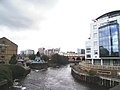 The River Aire and the Leeds-Liverpool canal in Leeds
 River Sheaf joins River Don at Sheffield
 Tidal Barrier on the River Hull at Kingston upon Hull
 Infinity Bridge on River Tees in the Borough of Stockton-on-Tees
 The road bridge at Stamford Bridge over the River Derwent
 River Wharfe at Tadcaster
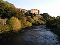 Richmond Castle and the River Swale
 River Ure at Boroughbridge
 River Nidd and railway viaduct at Knaresborough


.jpg)


