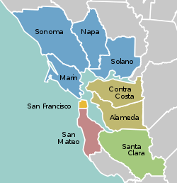
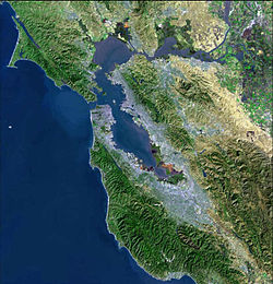
The San Francisco Bay Area Portal  The San Francisco Bay Area (referred to locally as the Bay Area) is a populous region surrounding the San Francisco and San Pablo estuaries in Northern California. The region encompasses the major cities and metropolitan areas of San Jose, San Francisco, and Oakland, along with smaller urban and rural areas. The Bay Area's nine counties are Alameda, Contra Costa, Marin, Napa, San Francisco, San Mateo, Santa Clara, Solano, and Sonoma. Home to approximately 7.68 million people, the nine-county Bay Area contains many cities, towns, airports, and associated regional, state, and national parks, connected by a network of roads, highways, railroads, bridges, tunnels, and commuter rail. The combined statistical area of the region is the second-largest in California (after the Greater Los Angeles area), the fifth-largest in the United States, and the 43rd-largest urban area in the world with 8.80 million people. The Bay Area has the second-most Fortune 500 companies in the United States, after the New York metropolitan area, and is known for its natural beauty, liberal politics, entrepreneurship, and diversity. The area ranks second in highest density of college graduates, after the Washington, D.C. metropolitan area and performs above the state median household income in the 2010 census; it includes the five highest California counties by per capita income and two of the top 25 wealthiest counties in the United States. Based on a 2013 population report from the California Department of Finance, the Bay Area is the only region in California where the rate of people migrating in from other areas in the United States is greater than the rate of those leaving the region, led by Alameda and Contra Costa counties. (more...) Selected article San Francisco Bay is in the U.S. state of California, surrounded by a contiguous region known as the San Francisco Bay Area (often simply "the Bay Area"), dominated by the large cities San Francisco, Oakland, and San Jose. The waterway entrance to San Francisco Bay from the Pacific Ocean is called the Golden Gate. Across the strait spans the Golden Gate Bridge. The bay was designated a Ramsar Wetland of International Importance on February 2, 2013. (more...) Selected biography Selected city San Bruno is located at 37°37′31″N 122°25′31″W / 37.625288°N 122.425266°W. The city is located between South San Francisco and Millbrae, adjacent to San Francisco International Airport and Golden Gate National Cemetery, and is approximately 12 miles (19 km) south of downtown San Francisco. According to the United States Census Bureau, the city has a total area of 5.5 square miles (14 km2), all of it land. The city spreads from the mostly flat lowlands near San Francisco Bay into the foothills of the Santa Cruz Mountains, which rise to more than 600 feet (180 m) above sea level in Crestmoor and more than 700 feet (210 m) above sea level in Portola Highlands. San Bruno City Hall sits at an official elevation of 41 feet (12.5 m) above sea level. (more...) Selected image Public sculpture near the University of California Botanical Garden and the Mathematical Sciences Research Institute, Berkeley Hills image credit: Bocardodarapti
The Bay Area by year1874
 
Selected historical imageDid you know...
Previous Did you know...  • ... that the Pacific Gas and Electric Company General Office Building and Annex (pictured, left), is a Beaux-Arts building designed by the Bakewell & Brown architecture firm? November 2014 Selected periodic event The Cotati Jazz Festival is an annual free music festival held in Cotati since 1980. It typically takes place on Father's Day weekend in mid-June. (the Susan Comstock Quintet pictured) Quote
Selected multimedia fileBay Area regions, geographic features and protected areasRelated PortalsWikiProject
Things you can do *Write an article on a Bay Area-related subject Selected panoramaSan Francisco Bay Area categoriesBay Area | San Francisco Bay | San Francisco | San Jose | Oakland | Cities | Census-designated places | Historic Places | National Landmarks | Counties: Alameda | Contra Costa | Marin | Napa | San Mateo | Santa Clara | Solano | Sonoma
Architecture | Attractions | Books | Culture | Economy | Education | Environment | Events & Festivals | Geography | Government | History | Landmarks | Law | Mass media | Military | Music | Organizations | Parks | People | Politics | Science | Sports | Transport
Full category tree
Select [►] to view the full category tree.
Associated WikimediaThe following Wikimedia Foundation sister projects provide more on this subject:
Discover Wikipedia using portals |
Purge server cache


