
| Buttercrambe | |
|---|---|
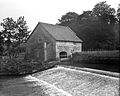
 The Old Corn Mill at Buttercrambe is now a private home | |
.svg) Buttercrambe Location within North Yorkshire | |
| OS grid reference | SE732581 |
| • London | 170 mi (270 km) S |
| Civil parish | |
| Unitary authority | |
| Ceremonial county | |
| Region | |
| Country | England |
| Sovereign state | United Kingdom |
| Post town | YORK |
| Postcode district | YO41 |
| Police | North Yorkshire |
| Fire | North Yorkshire |
| Ambulance | Yorkshire |
| UK Parliament | |
Buttercrambe is a small village in the Buttercrambe with Bossall civil parish, in North Yorkshire, England.[1][2] Buttercrambe is some 9 miles (14 km) north-east of York, and on average about 56 feet (17 m) above sea level.[3][4] The settlement is mentioned in the Domesday Book, and the name derives from the Old English of butere and crambe. Crambe is a word meaning bend, and so Buttercrambe's literal translation is rich piece of land in the bend of the river (Derwent).[5][6][7]
The village is situated approximately 8 miles (13 km) to the north-east of York and near the border with the East Riding of Yorkshire. It, with Bossall parish, had a recorded population of about 100 in the 2001 Census,[8] and 105 in the 2011 Census.[9] The village lies on the River Derwent, and Buttercrambe Mill, a former water-powered cornmill, is still on the riverside and is now a grade II listed building.[10][11]
The village was part of the Ryedale district between 1974 and 2023. It is now administered by North Yorkshire Council.
Aldby Hall and the Chapel of St John the Evangelist are at the centre of the village. Aldby park was the location that the Darley family brought the Darley Arabian to in 1704.[12] The church is 30-foot (9.1 m) by 15-foot (4.6 m), and has been tied to the parish church at Sand Hutton since 1404.[13] To the west of Buttercrambe, on high ground, are the remains of a Roman temporary camp: a square enclosure, ditched and banked, constructed quickly by an army on manoeuvres in enemy territory and used either overnight or for a short period of time, and demolished upon abandonment of the site.[14] The camp was constructed probably 20 years before the establishment of nearby Eboracum, Roman York, in 71 AD.[15]
The remains of Buttercrambe Castle lie in the village (to the east of Aldby Park). The castle fell to the Parliamentarians during a skirmish in the English Civil War.[16][17]
Gallery
-
 Buttercrambe Bridge in c. 1910
 -
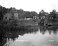
 Buttercrambe Weir in c. 1910
 -
 Buttercrambe Lock in c. 1910


References
- ^ Ordnance Survey: Landranger map sheet 105 York & Selby (Map). Ordnance Survey. 2014. ISBN 9780319229453.
- ^ "Ordnance Survey: 1:50,000 Scale Gazetteer" (csv (download)). www.ordnancesurvey.co.uk. Ordnance Survey. 1 January 2016. Retrieved 30 January 2016.
- ^ "Genuki: Bossall Supplementary, Yorkshire (North Riding)". genuki.org.uk. Retrieved 18 March 2024.
- ^ "Buttercrambe, Ryedale - area information, map, walks and more". getoutside.ordnancesurvey.co.uk. Retrieved 18 March 2024.
- ^ "Buttercrambe | Domesday Book". opendomesday.org. Retrieved 18 March 2024.
- ^ Ekwall, Eilert (1960). The concise Oxford dictionary of English place-names (4 ed.). Oxford: Oxford University Press. p. 128. ISBN 0-19-869103-3.
- ^ Smith, A. H. (1979) [1928]. The Place Names of the North Riding of Yorkshire. English Place Name Society. p. 36. OCLC 19714705.
- ^ UK Census (2001). "Local Area Report – Buttercrambe with Bossall Parish (36UF018)". Nomis. Office for National Statistics. Retrieved 18 March 2024.
- ^ UK Census (2011). "Local Area Report – Buttercrambe with Bossall Parish (E04007559)". Nomis. Office for National Statistics. Retrieved 18 March 2024.
- ^ "Water levels peak on River Derwent in East Yorkshire". BBC News. 27 September 2012. Retrieved 18 March 2024.
- ^ Historic England. "Buttercrambe Mill (Grade II) (1149648)". National Heritage List for England. Retrieved 18 March 2024.
- ^ Pevsner, Nikolaus (2002) [1966]. Yorkshire, the North Riding. London: Yale University Press. p. 94. ISBN 0300096658.
- ^ Page, William, ed. (1968). The Victoria history of the county of York, North Riding volume two. London: Dawsons of Pall Mall for the University of London Institute of Historical Research. p. 97. ISBN 0712903100.
- ^ "Buttercrambe Moor". heritagegateway.org.uk. Retrieved 18 March 2024.
- ^ Horne, Peter D.; Lawton, Ian G. (1998). "Buttercrambe Moor Roman Camp, Buttercrambe with Bossall, North Yorkshire (SE 7160 5695)". Britannia. 29: 327. doi:10.2307/526826.
- ^ "Buttercrambe Castle". heritagegateway.org.uk. Retrieved 18 March 2024.
- ^ Newman, Peter (1985). "1644: The Siege of York and War in the North-East". Atlas of the English Civil War. Routledge. doi:10.4324/9781003105954-20/1644-siege-york-war-north-east-peter-newman. Retrieved 18 March 2024.
External links
 Media related to Buttercrambe at Wikimedia Commons
- Buttercrambe in the Domesday Book