
No higher resolution available.
Cliffs_at_Easton_Wood,_near_Covehithe,_Suffolk_-_geograph.org.uk_-_52726.jpg (640 × 329 pixels, file size: 80 KB, MIME type: image/jpeg)
Summary
| Description |
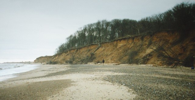
English: Cliffs at Easton Wood, near Covehithe, Suffolk. One of the fastest eroding parts of the coast. Easton Wood teeters on the top of the crumbling sand cliffs, whilst the North Sea prepares to attack once again. Several large trees have recently fallen down the cliff and wait to be washed away by the sea. Viewed looking S towards Southwold. |
| Date | |
| Source | From geograph.org.uk |
| Author | Pete Chapman |
| Attribution (required by the license) | Pete Chapman / Cliffs at Easton Wood, near Covehithe, Suffolk / |
| Object location | | View this and other nearby images on: OpenStreetMap |
|---|
_&language=en)
Licensing

|
This image was taken from the Geograph project collection. See this photograph's page on the Geograph website for the photographer's contact details. The copyright on this image is owned by Pete Chapman and is licensed for reuse under the Creative Commons Attribution-ShareAlike 2.0 license.
|
This file is licensed under the Creative Commons Attribution-Share Alike 2.0 Generic license.
Attribution: Pete Chapman
- You are free:
- to share – to copy, distribute and transmit the work
- to remix – to adapt the work
- Under the following conditions:
- attribution – You must give appropriate credit, provide a link to the license, and indicate if changes were made. You may do so in any reasonable manner, but not in any way that suggests the licensor endorses you or your use.
- share alike – If you remix, transform, or build upon the material, you must distribute your contributions under the same or compatible license as the original.
File history
Click on a date/time to view the file as it appeared at that time.
| Date/Time | Thumbnail | Dimensions | User | Comment | |
|---|---|---|---|---|---|
| current | 13:54, 30 January 2010 | | 640 × 329 (80 KB) | GeographBot | == {{int:filedesc}} == {{Information |description={{en|1=Cliffs at Easton Wood, near Covehithe, Suffolk. One of the fastest eroding parts of the coast. Easton Wood teeters on the top of the crumbling sand cliffs, whilst the North Sea prepares to attack on |
File usage
The following pages on the English Wikipedia use this file (pages on other projects are not listed):
Global file usage
The following other wikis use this file:
- Usage on ja.wikipedia.org