
No higher resolution available.
Former_Wallington_town_hall_geograph-3360622-by-Marathon.jpg (640 × 480 pixels, file size: 354 KB, MIME type: image/jpeg)
Summary
| Description |
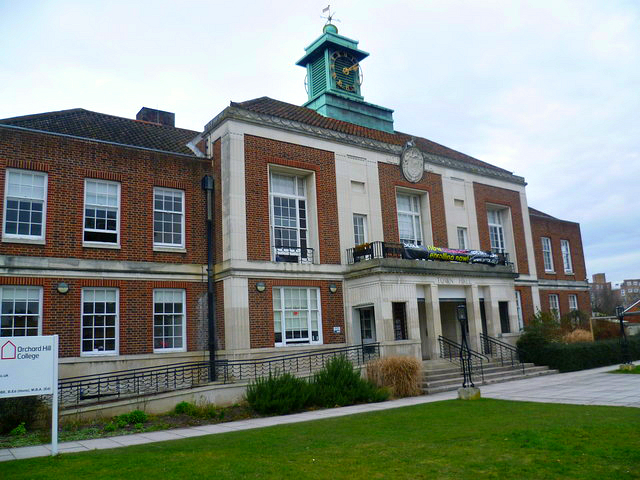
English: After the First World War, the population of Wallington increased rapidly and the local Urban District Council outgrew its various offices and so, in 1929, purchased an old house, Sunny Bank, in Woodcote Road and decided to commission a new Town Hall, to be built on Sunny Banks site. The Council became a Borough in 1937, and the Town Hall was the hub of community life up until the incorporation of Beddington and Wallington into the London Borough of Sutton in 1964, and even then, the Council Chamber was used for the new Council's meetings until 1977. Parts of the building continued to be used by other organisations such as the WRVS, the Registrar of Births, Marriages and Deaths, and as a Driving Test Centre. In 1980 it was taken over and converted into a Crown Court. The building ceased to be a Court in April 1999, and has now been converted for educational use. |
| Date | |
| Source | https://www.geograph.org.uk/reuse.php?id=3360622 |
| Author | Marathon |
| Attribution (required by the license) | Marathon / Former town hall, Wallington / |
| Camera location | | View this and other nearby images on: OpenStreetMap |
|---|
Licensing

|
This image was taken from the Geograph project collection. See this photograph's page on the Geograph website for the photographer's contact details. The copyright on this image is owned by Marathon and is licensed for reuse under the Creative Commons Attribution-ShareAlike 2.0 license.
|
This file is licensed under the Creative Commons Attribution-Share Alike 2.0 Generic license.
Attribution: Marathon
- You are free:
- to share – to copy, distribute and transmit the work
- to remix – to adapt the work
- Under the following conditions:
- attribution – You must give appropriate credit, provide a link to the license, and indicate if changes were made. You may do so in any reasonable manner, but not in any way that suggests the licensor endorses you or your use.
- share alike – If you remix, transform, or build upon the material, you must distribute your contributions under the same or compatible license as the original.
File history
Click on a date/time to view the file as it appeared at that time.
| Date/Time | Thumbnail | Dimensions | User | Comment | |
|---|---|---|---|---|---|
| current | 01:42, 19 January 2015 | | 640 × 480 (354 KB) | A P Monblat | adj |
| 20:30, 12 September 2014 |  | 640 × 480 (74 KB) | A P Monblat | User created page with UploadWizard |
File usage
The following pages on the English Wikipedia use this file (pages on other projects are not listed):
Global file usage
The following other wikis use this file:
- Usage on nl.wikipedia.org