

Size of this PNG preview of this SVG file: 513 × 600 pixels. Other resolutions: 205 × 240 pixels | 410 × 480 pixels | 657 × 768 pixels | 876 × 1,024 pixels | 1,751 × 2,048 pixels | 1,116 × 1,305 pixels.
Original file (SVG file, nominally 1,116 × 1,305 pixels, file size: 1.53 MB)
Summary
| Description |
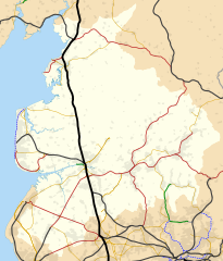
English: Map of Lancashire, England with the following information shown:
Equirectangular map projection on WGS 84 datum, with N/S stretched 165% Geographic limits:
Primary route
Secondary route
Rural route
Goods only
Disused railway |
| Date | (UTC) |
| Source |
This file was derived from: Lancashire UK location map.svg:  |
| Author |
|
Licensing
I, the copyright holder of this work, hereby publish it under the following license:
This file is licensed under the Creative Commons Attribution-Share Alike 3.0 Unported license.
Attribution: Dr Greg and Nilfanion. Contains Ordnance Survey data © Crown copyright and database right 2010
- You are free:
- to share – to copy, distribute and transmit the work
- to remix – to adapt the work
- Under the following conditions:
- attribution – You must give appropriate credit, provide a link to the license, and indicate if changes were made. You may do so in any reasonable manner, but not in any way that suggests the licensor endorses you or your use.
- share alike – If you remix, transform, or build upon the material, you must distribute your contributions under the same or compatible license as the original.
References
- (1929) Combined index shewing parishes and the Ordnance Survey of Lancashire archive copy at the Wayback Machine, Ordnance Survey, copy online at Lancashire County Council website accessed 22 July 2012
- Wignall, C.J. (1983), Complete British Railways Maps and Gazetteer from 1830–1981, Oxford Railway Publishing Company, Oxford, ISBN 0 86093 162 5
- (2011) Network Specification 2011 – London North Western archive copy at the Wayback Machine, Network Rail, London, p.24, accessed 23 July 2012
- (1947–1957) Ordnance Survey New Popular Edition maps, copy online at New Popular Edition Maps website, accessed 14 August 2012
Original upload log
This image is a derivative work of the following images:
- File:Lancashire_UK_location_map.svg licensed with Cc-by-sa-3.0
- 2010-09-26T18:59:56Z Nilfanion 1116x1305 (2414104 Bytes) {{Information |Description=Map of [[w:Lancashire|Lancashire]], UK with the following information shown: *Administrative borders *Coastline, lakes and rivers *Roads and railways *Urban areas Equirectangular map projection on
Uploaded with derivativeFX
File history
Click on a date/time to view the file as it appeared at that time.
| Date/Time | Thumbnail | Dimensions | User | Comment | |
|---|---|---|---|---|---|
| current | 16:59, 11 September 2012 | | 1,116 × 1,305 (1.53 MB) | Dr Greg | more accuracy in disused line routes |
| 19:50, 26 July 2012 |  | 1,116 × 1,305 (1.48 MB) | Dr Greg | Lines recoloured to match Network Rail's classification of lines; and more accurate Metrolink lines. | |
| 21:49, 22 July 2012 |  | 1,116 × 1,305 (1.63 MB) | Dr Greg | == {{int:filedesc}} == {{Information |Description={{en|Map of Lancashire, England with the following information shown: *County border *Coastline and lakes *Railways (see below) *Urban areas Equirectangular map projection on WGS ... |
File usage
The following pages on the English Wikipedia use this file (pages on other projects are not listed):