

Original file (2,280 × 1,074 pixels, file size: 1.17 MB, MIME type: image/png)
Summary
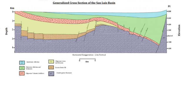
utdlabrador, after B. Brister & R. Gries, Tertiary Stratigraphy and Tectonic Development of the Alamosa Basin (Northern San Luis Basin), Rio Grande Rift, South Central Colorado.
Licensing
| I, the copyright holder of this work, release this work into the public domain. This applies worldwide. In some countries this may not be legally possible; if so: I grant anyone the right to use this work for any purpose, without any conditions, unless such conditions are required by law. |
FYI, the legend on this diagram has an error. The green color (2nd-youngest division shown) is labeled "Paleocene alluvium and sediments". However, the Paleocene Epoch is older than the Eocene and Oligocene-age layers shown on the map, so this cannot be the correct name for sediments in this upper layer. This color must represent Miocene + Pliocene sediments, which collectively are grouped as the rocks of the Neogene Period.
File history
Click on a date/time to view the file as it appeared at that time.
| Date/Time | Thumbnail | Dimensions | User | Comment | |
|---|---|---|---|---|---|
| current | 07:12, 5 December 2010 | | 2,280 × 1,074 (1.17 MB) | Utdlabrador | utdlabrador, after B. Brister & R. Gries, '''Tertiary Stratigraphy and Tectonic Development of the Alamosa Basin (Northern San Luis Basin), Rio Grande Rift, South Central Colorado'''. |
File usage
Global file usage
The following other wikis use this file:
- Usage on hy.wikipedia.org