
Size of this JPG preview of this PDF file: 423 × 599 pixels. Other resolutions: 169 × 240 pixels | 339 × 480 pixels | 542 × 768 pixels | 1,239 × 1,754 pixels.
Original file (1,239 × 1,754 pixels, file size: 4.38 MB, MIME type: application/pdf)
Summary
| Description |
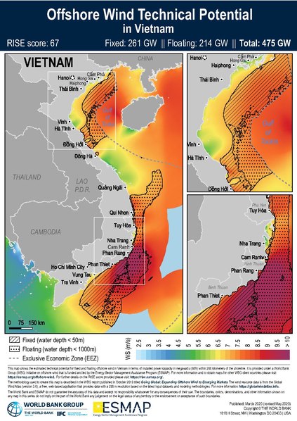
English: This map is provided under a World Bank Group (WBG) initiative on offshore wind that is funded and led by the Energy Sector Management Assistance Program (ESMAP). For more information and to obtain maps for other WBG client countries please visit: https://esmap.org/node/197070. For further details on the RISE score provided please visit: https://rise.esmap.org/.
The methodology used to create this map is described in the WBG report published in October 2019 titled "Going Global: Expanding Offshore Wind to Emerging Markets". The wind resource data is from the Global Wind Atlas (version 3.0), a free, web-based application that provides data with a 250 m resolution based on the latest input datasets and modeling methodologies. For more information: https://globalwindatlas.info. |
| Date | |
| Source | http://documents1.worldbank.org/curated/en/340451572465613444/pdf/Technical-Potential-for-Offshore-Wind-in-Vietnam-Map.pdf |
| Author | World Bank |
Published: March 2020 (revised May 2020) Copyright © THE WORLD BANK 1818 H Street, NW | Washington DC 20433 | USA
The World Bank and ESMAP do not guarantee the accuracy of this data and accept no responsibility whatsoever for any consequences of their use. The boundaries, colors, denominations, and other information shown on any map in this series do not imply on the part of the World Bank any judgement on the legal status of any territory or the endorsement or acceptance of such boundaries.
Licensing
This file is licensed under the Creative Commons Attribution 4.0 International license.
- You are free:
- to share – to copy, distribute and transmit the work
- to remix – to adapt the work
- Under the following conditions:
- attribution – You must give appropriate credit, provide a link to the license, and indicate if changes were made. You may do so in any reasonable manner, but not in any way that suggests the licensor endorses you or your use.
File history
Click on a date/time to view the file as it appeared at that time.
| Date/Time | Thumbnail | Dimensions | User | Comment | |
|---|---|---|---|---|---|
| current | 15:00, 23 October 2020 |  | 1,239 × 1,754 (4.38 MB) | O-Jay | Uploaded a work by World Bank from http://documents1.worldbank.org/curated/en/340451572465613444/pdf/Technical-Potential-for-Offshore-Wind-in-Vietnam-Map.pdf with UploadWizard |
File usage
The following pages on the English Wikipedia use this file (pages on other projects are not listed):