
Morden Road | |
|---|---|
 | |
| General information | |
| Location | Merton Park, London Borough of Merton England |
| Operated by | Tramlink |
| Platforms | 2 |
| Construction | |
| Accessible | Yes |
| Other information | |
| Fare zone | London fare zones 3, 4, 5 and 6 |
| History | |
| Opened | 30 May 2000 |
| Passengers | |
| 2009–10 | 0.430 million total boardings and alightings[1] |
| 2010–11 | |
Morden Road is a Tramlink stop in the London Borough of Merton. It is on the site of the former Morden Road railway station on the Wimbledon-West Croydon line, which closed to rail traffic in 1997. The tram stop consists of two platforms on either side of the double track, linked by pedestrian level crossings. Immediately to the east of the station is a single-track section which reaches as far as Phipps Bridge tram stop.
The eastbound platform is directly linked by ramp and stairway to Morden Road. The town centre of Morden lies 0.5 mi (0.80 km) to the south. A pedestrian entrance to the National Trust's Morden Hall Park is on Morden Road just to the south of the stop.
The stop is interlinked as an out of station interchange (OSI) with South Wimbledon on the London Underground's Northern line. The two stations are classed as an interchange for ticketing purposes but both managed separately.
Connections
London Buses routes 93, 470 and night route N155 serve the tram stop.
Future

A planned new line to the Tramlink light rail or a separate bus rapid transit (BRT) system called the Sutton Link will create a new tram or BRT with existing tram services for interchange with new platforms built at Morden Road somewhere close to the current tram stop, offering services to Sutton via St Helier or South Wimbledon via Morden Road.[3][4]
Gallery
-
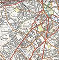 A 1944 Ordnance Survey of Morden area showing the location of the former station, now a tram stop
 -
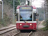 Tramlink tram 2536 approaches Morden Road tram stop with an eastbound route 2 service to Beckenham Junction station, 2006
 -
 A sign directing passengers to Morden Road tram stop, or Morden tube station.


| Preceding station | Following station | |||
|---|---|---|---|---|
| Merton Park towards Wimbledon
|
Tramlink Wimbledon to Beckenham Junction |
Phipps Bridge towards Beckenham Junction
| ||
| Tramlink Wimbledon to Elmers End |
Phipps Bridge towards Elmers End
| |||
References
- ^ "Tram Stop Usage 2009-10 (FOI)" (XLS). Tramlink annual passenger performance 2009-2010. Transport for London. 18 August 2011. Retrieved 28 November 2012.
- ^ "Tramlink numbers 2010-2011" (PDF). Tramlink annual passenger performance 2010-2011. Transport for London. 28 March 2012. Retrieved 28 November 2012.
- ^ White, Anna (26 September 2017). "Exclusive: Tramlink extension set to bring 10,000 new homes to south-west London as TfL promises £70m to project". Evening Standard. Retrieved 27 September 2017.
- ^ "Have your say on the Sutton Link: A major new public transport service for Sutton and Merton - Transport for London - Citizen Space".
51°24′32″N 0°11′34″W / 51.408843°N 0.192904°W
| Tram stops |
| ||||||||
|---|---|---|---|---|---|---|---|---|---|
| Proposed developments |
| ||||||||
| Rolling stock | |||||||||
| Related topics | |||||||||