The North America Portal

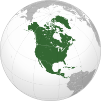
North America is a continent in the Northern and Western Hemispheres. North America is bordered to the north by the Arctic Ocean, to the east by the Atlantic Ocean, to the southeast by South America and the Caribbean Sea, and to the west and south by the Pacific Ocean. Greater North America includes the Bahamas, Bermuda, Canada, the Caribbean, Central America, Clipperton Island, Greenland, Mexico, Saint Pierre and Miquelon, Turks and Caicos Islands, and the United States.
Continental North America covers an area of about 24,709,000 square kilometers (9,540,000 square miles), representing approximately 16.5% of the Earth's land area and 4.8% of its total surface area. It is the third-largest continent by size after Asia and Africa, and the fourth-largest continent by population after Asia, Africa, and Europe. , North America's population was estimated as over 592 million people in 23 independent states, or about 7.5% of the world's population. In human geography, the terms "North America" and "North American" sometimes refer to just Canada, the United States, Mexico, and Greenland.
It is unknown with certainty how and when first human populations first reached North America. People were known to live in the Americas at least 20,000 years ago but various evidence points to possibly earlier dates. The Paleo-Indian period in North America followed the Last Glacial Period, and lasted until about 10,000 years ago when the Archaic period began. The classic stage followed the Archaic period, and lasted from approximately the 6th to 13th centuries. Beginning in 1000 AD, the Norse were the first Europeans to begin exploring and ultimately colonizing areas of North America.
In 1492, the exploratory voyages of Christopher Columbus led to a transatlantic exchange, including migrations of European settlers during the Age of Discovery and the early modern period. Present-day cultural and ethnic patterns reflect interactions between European colonists, indigenous peoples, African slaves, immigrants from Europe, Asia, and descendants of these respective groups. (Full article...)
Wood Badge is a Scouting leadership programme and the related award for adult leaders in the programmes of Scout associations throughout the world. Wood Badge courses aim to make Scouters better leaders by teaching advanced leadership skills, and by creating a bond and commitment to the Scout movement. Courses generally have a combined classroom and practical outdoors-based phase followed by a Wood Badge ticket, also known as the project phase. By "working the ticket", participants put their newly gained experience into practice to attain ticket goals aiding the Scouting movement. The first Wood Badge training was organized by Francis "Skipper" Gidney and lectured at by Robert Baden-Powell and others at Gilwell Park (United Kingdom) in September 1919. Wood Badge training has since spread across the world with international variations.
On completion of the course, participants are awarded the Wood Badge beads to recognize significant achievement in leadership and direct service to young people. The pair of small wooden beads, one on each end of a leather thong (string), is worn around the neck as part of the Scout uniform. The beads are presented together with a taupe neckerchief bearing a tartan patch of the Maclaren clan, honoring William de Bois Maclaren, who donated the £7000 to purchase Gilwell Park in 1919 plus an additional £3000 for improvements to the house that was on the estate. The neckerchief with the braided leather woggle (neckerchief slide) denotes the membership of the 1st Gilwell Scout Group or Gilwell Troop 1. Recipients of the Wood Badge are known as Wood Badgers or Gilwellians. (Full article...)
Charles Edward Magoon (December 5, 1861 – January 14, 1920) was an American lawyer, judge, diplomat, and administrator who is best remembered as a governor of the Panama Canal Zone; he also served as Minister to Panama at the same time. He was Provisional Governor of Cuba during the American occupation of Cuba from 1906 to 1909.
He was the subject of several scandals during his career. As a legal advisor working for the United States Department of War, he drafted recommendations and reports that were used by Congress and the executive branch in governing the United States' new territories following the Spanish–American War. These reports were collected as a published book in 1902, then considered the seminal work on the subject. During his time as a governor, Magoon worked to put these recommendations into practice. In summary: Magoon was hugely successful in Panama but criticized for his tenure in Cuba. (Full article...)
Did you know...
- ...that the proposed Atlantica trade bloc would economically tie New England in the U.S. to the Atlantic Provinces of Canada?
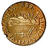
- ... that Vermont coppers (pictured) were the currency used in Vermont before it became a U.S. state in 1791?
- ...that Tropical Storm Larry caused five deaths and US$53.6 million in damage when it struck the Tabasco state of Mexico, the first landfall in the state since 1973?
- ... that the Chontal Maya of Tabasco consider themselves the direct descendants of the Olmec civilization?
- ... that the book The Complex: How the Military Invades Our Everyday Lives explores U.S. military expenditures on items including Southern catfish restaurants and Dunkin' Donuts?
Selected panorama

Topics
Categories
List articles
Related portals
Northern America
Central America
Caribbean
WikiProjects
 North America
-
 Canada
 -
 Greenland
 -
 Mexico
 -
 Saint Pierre and Miquelon
 -
 United States
  Central America
-
 Belize
 -
 Costa Rica
 -
 El Salvador
 -
 Guatemala
 -
 Honduras
 -
 Nicaragua
 -
 Panama
  Mesoamerica
 Caribbean
-
 Antigua and Barbuda
 -
 Bahamas
 -
 Barbados
 -
 Bermuda
 -
 Cuba
Cuba -
 Dominica
 -
 Dominican Republic
 -
 Grenada
 -
 Haiti
Haiti -
 Jamaica
 -
 Puerto Rico
 -
 Saint Kitts and Nevis
 -
 Saint Lucia
 -
 Saint Vincent and the Grenadines
 -
 Trinidad and Tobago
Associated Wikimedia
The following Wikimedia Foundation sister projects provide more on this subject:
-
 Commons
Free media repository -
 Wikibooks
Free textbooks and manuals -
 Wikidata
Free knowledge base -
 Wikinews
Free-content news -
 Wikiquote
Collection of quotations -
 Wikisource
Free-content library -
 Wikiversity
Free learning tools -
 Wikivoyage
Free travel guide -
 Wiktionary
Dictionary and thesaurus


