| West Lutton | |
|---|---|
.svg) West Lutton Location within North Yorkshire | |
| Population | 411 (2011 census)[1] |
| OS grid reference | SE931694 |
| • London | 180 mi (290 km) S |
| Civil parish | |
| Unitary authority | |
| Ceremonial county | |
| Region | |
| Country | England |
| Sovereign state | United Kingdom |
| Post town | MALTON |
| Postcode district | YO17 |
| Police | North Yorkshire |
| Fire | North Yorkshire |
| Ambulance | Yorkshire |
| UK Parliament | |
West Lutton is a village in North Yorkshire, England. It is situated approximately 9 miles (14 km) east from Malton, and within the Yorkshire Wolds. The hamlet of East Lutton is 0.5 miles (0.8 km) to the east. The village lies in the Great Wold Valley and the course of the winterbourne stream the Gypsey Race passes through it.
They are recorded in the Domesday Book in 1086 as one location, and were home to at least five families.[2] In common with other villages at the time, the Luttons suffered during William the Conqueror's Harrying of the North, during which many farms and homesteads were laid waste, evidenced by the dramatic drop in their annual contribution to the local landowner: from £14 in 1066 to less than £1 in 1086.[2]
West Lutton forms part of the civil parish of Luttons.
It was historically part of the East Riding of Yorkshire until 1974 and in the Ryedale district from 1974 to 2023.
The village church, St Mary's, is designated a Grade II* listed building.[3] The church contains a sculpture by the Derbyshire sculptor James Redfern.[4]
In 1823 West Lutton was in the parish of Weaverthorpe, the Wapentake of Buckrose, and the Liberty of St Peter's in the East Riding of Yorkshire. Population, including East Lutton was 311. West Lutton occupations included six farmers, one of whom was also a grocer and another a wheelwright, two further wheelwrights, a blacksmith, two shoemakers, two tailors, and the landlord of The Board public house.[5]
Gallery
-
 West Lutton from Malton Lane
 -
 St Mary's Church, West Lutton
 -
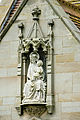 Sculpture by James Redfern
.JPG)
.jpg)

References
- ^ UK Census (2011). "Local Area Report – Luttons Parish (1170217267)". Nomis. Office for National Statistics. Retrieved 22 March 2018.
- ^ a b Powell-Smith, Anna. "[East and West] Lutton | Domesday Book". opendomesday.org. Retrieved 13 September 2016.
- ^ Historic England. "Church of St Mary (1149659)". National Heritage List for England. Retrieved 21 October 2014.
- ^ Pevsner, Nikolaus; Neave, David (2002). Yorkshire : York and the East Riding (2 ed.). London: Yale University Press. p. 94. ISBN 0-300-09593-7.
- ^ Baines, Edward (1823): History, Directory and Gazetteer of the County of York, p. 365
External links
 Media related to West Lutton at Wikimedia Commons